
INDIAN SPACE RESEARCH SATELLITES
CARTOSAT 2b
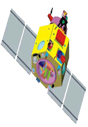 CARTOSAT - 2B is the seventeenth satellite in the Indian Remote Sensing Satellite series (IRS). CARTOSAT-2B carries a Panchromatic camera (PAN) similar to those of its predecessors - CARTOSAT-2 and 2A.
It is capable of imaging a swath (geographical strip) of 9.6 km with a resolution of better than 1 metre. The scene specific spot imagery sent by CARTOSAT-2B's PAN will be useful for cartographic and a host of other applications.
The highly agile CARTOSAT-2B is steerable up to ± 26o along as well as across track to obtain stereoscopic imagery and achieve a four to five day revisit capability.
CARTOSAT - 2B is the seventeenth satellite in the Indian Remote Sensing Satellite series (IRS). CARTOSAT-2B carries a Panchromatic camera (PAN) similar to those of its predecessors - CARTOSAT-2 and 2A.
It is capable of imaging a swath (geographical strip) of 9.6 km with a resolution of better than 1 metre. The scene specific spot imagery sent by CARTOSAT-2B's PAN will be useful for cartographic and a host of other applications.
The highly agile CARTOSAT-2B is steerable up to ± 26o along as well as across track to obtain stereoscopic imagery and achieve a four to five day revisit capability.
| Mission | Remote Sensing |
| Weight | 694 kg (Mass at lift off) |
| Onboard Orbit | 930 Watts |
| Stabilization | 3 – axis body stabilised based on inputs from star sensors and gyros using Reaction wheels, Magnetic Torquers and Hydrazine Thrusters |
| Payloads | Panchromatic Camera |
| Launch date | July 12, 2010 |
| Launch site | SHAR Centre Sriharikota India |
| Launch vehicle | PSLV- C15 |
| Orbit | 630 kms, Polar Sun Synchronous |
| Inclination | 97.71º |